Most people turning into Griffiths Way would never guess the origins of the land on the corner stretching from the Abbey View office development through to Sainsbury’s supermarket. Some may remember the gasworks which occupied the site before the retail park but are unlikely to know that it was once part of a meadow called Woad Mead (sometimes called Wot Mead, Wat Mead, Wood Mead or Wood Close). Woad Mead was in Eywood in medieval times. Eywood extended from the present day Abbey Station towards Park Street and would have included Sopwell.
The land in this area was principally water meadow. The name Woad Mead may relate to the wetness of the land, though it is more likely to relate to the growing and processing of woad, which would have been a crop needed to dye wool in medieval times when the wool and woollen textile industry was significant in this country. Added to this, a path (probably an ancient trade route) passed through Woad Mead connecting the Abbey, via Fullers Street (later called Mud Lane) across what is now Verulamium Park, with Watling Street at St Julian’s and onwards to the London markets. 17th century maps identify part of this path as Eywood Lane. The road by the gasworks was called Eywood Road before it became Griffiths Way.
Its position and ownership is confusing. Woad Mead lay within St Stephen’s parish but was in the manor of Sopwell and so part of St Peter’s parish. The earliest maps of the area show it within the ancient borough of St Albans. In the 16th century, the land belonged to the owners of Sopwell and later the owners of the St Julian’s estate. However, there was a 2½ acre strip across the middle of it which belonged to the Churchwardens of St Peter’s parish for the benefit of its poor. See the extract from the plan of St Julian’s 1814 below. The history of this important strip of land from 16th century until its sale in the early 19th century confirms its ownership by rental agreements and payments.
Following the Dissolution of the Monasteries, much of the lands in this area were granted to Sir Richard Lee, one of Henry’s military engineers. Not content with having all this land including Woad Mead to use, he decided that he also wanted to utilise the narrow strip of land across the middle belonging to St Peter’s. So, in 1545 the land, described then as a barn field of five acres, was leased to him at an annual rent of eight shillings. It is not explained exactly why Lee wanted this strip of land but it was obviously important to him. It probably made sense to join it up with his other lands and some years later this is what he did. He demolished the barn, pulled up all the hedges and merged the land with his own. One reason, could be that the land was used for deer hunting. Having restricted access to a strip of land in the middle of a chase would have been a great inconvenience. When Lee passed away, his daughter Mary, who married Humphrey Coningsby and then Ralph Pemberton, continued to lease this strip of land from St Peter’s parish and pay the rent. Mary Pemberton died in 1610 her lands, including the lease of Woad Mead were inherited by her nephew, Richard Sadleir. He shared the land with William Packington and the pair of them disputed the rent, now raised to 20 shillings, and refused to pay. This resulted in a court case. It did not help the church wardens of St Peter’s parish that the original deed of ownership could not be found and that the boundaries of the land were vague. In 1616, the case was heard in the High Court of Chancery which confirmed the entitlement of St Peter’s to a rental. The court determined that the defendants were not allowed to plough it or despoil it by ploughing or otherwise and they had to pay the arrears. Sir Thomas Pope Blount and Sir John Luke were appointed to determine the boundaries of the land in question, for which Sadler and Packington were obliged to pay rent. In the description the land on the west upon the highway was 8 poles from the hedge and ditch, to the north land 48 poles.
In 1663 Robert Sadleir a descendant of Richard sold Woad Mead to John Ellis. The sale obviously excluded the strip in the middle. Ellis was a woollen merchant who, in 1649, had bought the estate at St Julian’s. Woad Mead then passed down through the owners of St Julian’s ending with William Wilshere and his heirs. By 1803, the St Julian’s mansion had been demolished. John Willan, a tenant farmer of St Julian’s, was the last to farm the St Peter’s strip as it was not included in the lease of the next tenant farmer, John Gomme. The Woad Mead strip continued to be let out by public auction to various people who appeared to have no interest in farming. One was a blacksmith, another a wheelwright and the last one was a warehouseman. One could see from the description of the plans (see image below) that this piece of land in Woad Mead exactly fitted the area later occupied by the gasworks. This proved to be so. The land belonging to St Peter’s parish was finally sold off. Initially it was leased to the St Albans Gas Company in 1831 and then the freehold was purchased in 1872.
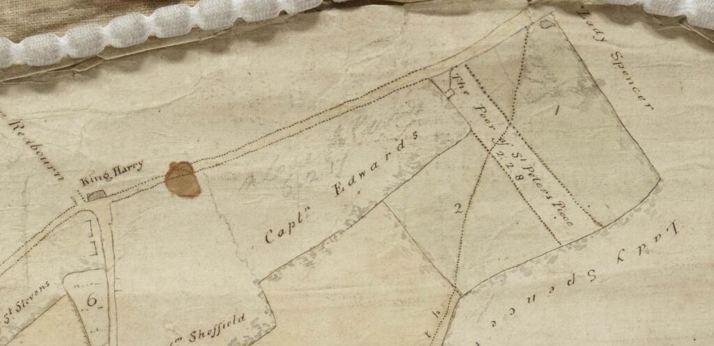
1825 plan of St Julian’s 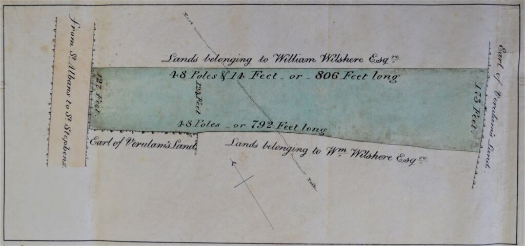
Plan of lease


How interesting – I never knew Mud Lane was ever known as anything else, and I often used to wonder who “Sadleir” was, after whom Sadlier Road is named; I had a school friend who lived there!
Very interesting. Thank you
Thanks Sandy. Lots of info there.
There’s a lot more detail, Derek, which I decided not to include. I was hoping to publish it.