If we look at some of the older maps of the Sopwell area we can see clearly where some of the footpaths were. A few of these paths are still in existence. Many of the later estate roads followed the line of the footpaths which linked to important buildings, farms and churches. Also, Sopwell being in the south of the city would have been a gateway to London and beyond.
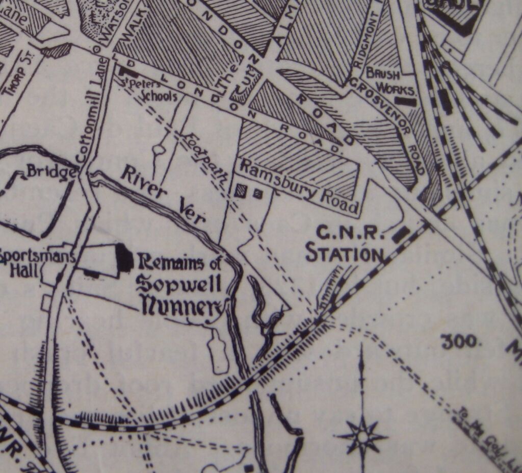
The main highway to St Albans from London was a Roman road part of the original parish boundary. This is the highway that Sir Richard Lee diverted as he did not like it being too close to the boundary of his property (New Barnes House now Sopwell House Hotel) and so in 1562 the “traffic” was diverted down what is now Old London Road. The original London Road is now the footpath which crosses Verulam golf course from Cottonmill Lane and takes a line through Riverside Road, past the Jim Green memorial Scout hut and Henrys Grant and along the footpath on the right, then across the Cottonmill Lane/Watson’s Walk roundabout through to Sopwell Lane. The path is clearly shown on the 1922 map above.
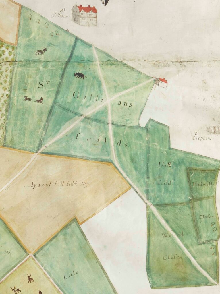
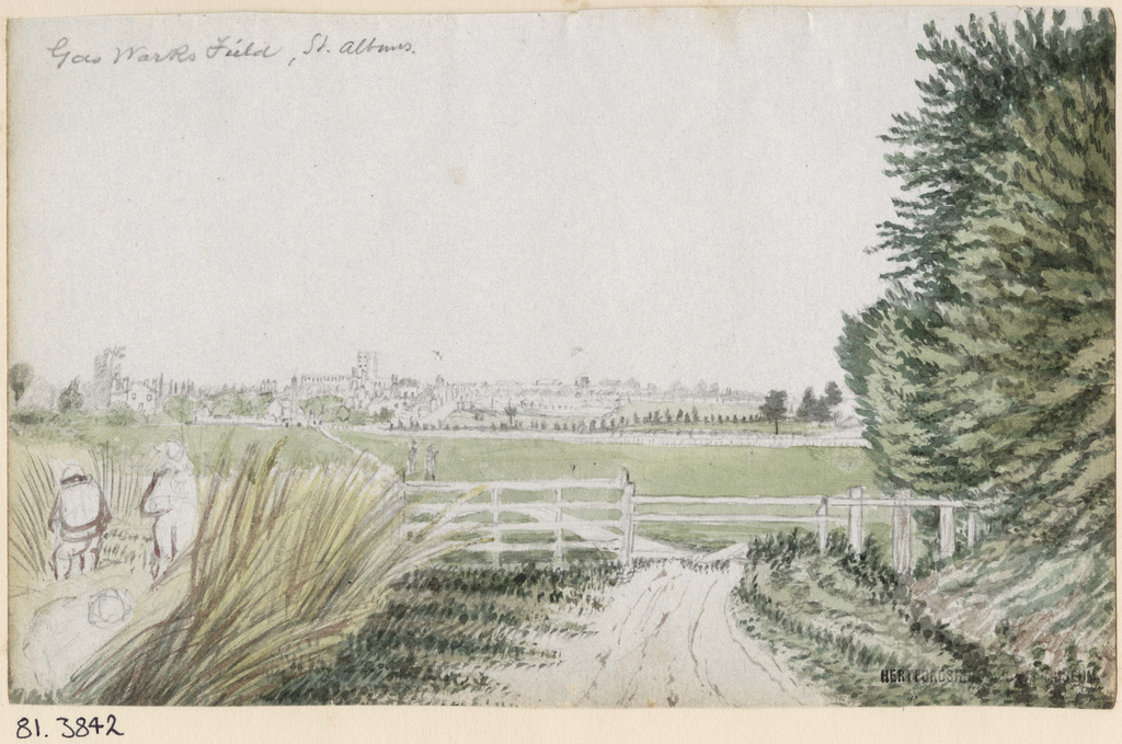
Another major highway from London and elsewhere came via Watling Street. Old maps show a footpath joining Watling Street down to the gasworks. Today this is where Vesta Avenue, and Wilshere Avenue/Doggetts Way are now. The path did not stop at the gasworks. The gasworks, now a retail development, were built on a piece of land called Woad Mead. The footpath crossed Woad Mead and then joined the route to the town and its markets. In medieval times, it would have been an important trade route used by the woollen industry in St Albans. We know there were barns on Woad Mead which were likely to have been used as storage for fleeces. This footpath would also have connected the St Julian’s leper hospital and later St Julian’s mansion to the town as it was directly opposite. See the 1666 extract of a map of Sopwell below which shows St Gillians (St Julian’s) and the footpath going through Woad Close (Woad Mead). Also the watercolour painting by J.H. Buckingham called Gasworks Field clearly shows the footpath. The route remained of value to local people through the 19th century when public access “to this delightful right of way” was confirmed following a dispute with the manager of the gasworks.
The other footpath on the 1666 map which crosses the one above is still in existence. It once connected St Julian’s farm to Hedges farm. It runs in more or less in a straight line from Watling Street, almost opposite Marlborough Academy, through to Wilshere Avenue and Doggetts Way. It then veers right to pass between Tavistock Avenue and Maynard Drive down Mandeville Drive and crosses over Creighton Avenue and down to Holyrood Crescent. It then crosses the green space past the children’s play area to the railway bridge and what was once Little Sopwell Farm. Before the North Orbital was built it would have gone over the fields to Hedges Farm. It also connects with what was New Barnes Farm, now Sopwell House Hotel.

Latest comments